


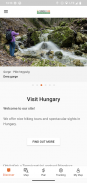

Természetjáró, a túratervező
Description of Természetjáró, a túratervező
হাঙ্গেরির অনলাইন ট্যুরিস্ট গাইড, বিশেষভাবে হাইকার, বাইকার, ট্রেইলরানার, রকক্লাইম্বার এবং ওয়াটার স্পোর্টস প্রেমীদের জন্য তৈরি করা হয়েছে, যেখানে একটি বিল্ট-ইন ট্যুর প্ল্যানার, সেইসাথে শত শত প্রস্তাবিত ট্যুর এবং হাজার হাজার দর্শনীয় স্থান রয়েছে, সবই বিশদ বিবরণ এবং প্রচুর ফটোগ্রাফ সহ , একটি ইন্টারেক্টিভ মানচিত্রে আরামদায়কভাবে দেখা যায়। বর্ধিত কার্যকারিতার জন্য সাবস্ক্রিপশন বিকল্প সহ বিনামূল্যে উপলব্ধ।
বৈশিষ্ট্য
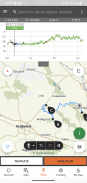
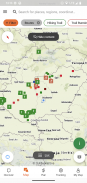
• বিভিন্ন ইন্টারেক্টিভ, জুমযোগ্য, ভেক্টরাইজড, বিশ্বব্যাপী হাইকিং ম্যাপ সমস্ত চিহ্নিত ট্রেইল সহ, আপনার বর্তমান অবস্থান দেখায়
• মানচিত্রে আপনার নিজস্ব ভ্রমণের পরিকল্পনা করার একটি সুবিধাজনক উপায়, এবং অবিলম্বে দৈর্ঘ্য, সময়কাল এবং উচ্চতা প্রোফাইল পান
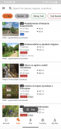
• এক হাজারেরও বেশি প্রস্তাবিত ট্যুর হাইকার, বাইকার, ট্রেইল রানার এবং ক্যানোয়ারদের জন্য, ব্যবহারিক ডেটা সহ, কাছাকাছি সেরা দর্শনীয় স্থানগুলির বিশদ বিবরণ, প্রাকৃতিক এবং সাংস্কৃতিক পটভূমি, ভাল মানের ফটোগ্রাফ এবং কীভাবে সেখানে যেতে হবে তার তথ্য।
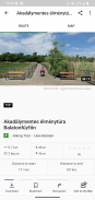
• হাঙ্গেরিতে হাজার হাজার প্রস্তাবিত দর্শনীয় স্থান, যার মধ্যে রয়েছে লুকআউট টাওয়ার, প্রাকৃতিক প্যানোরামা পয়েন্ট, ফরেস্ট ট্রেন, দুর্গ এবং জাদুঘর, বিশদ বিবরণ সহ, ভাল মানের ফটোগ্রাফ এবং সেখানে কীভাবে যেতে হবে তার তথ্য সহ
• চিহ্নিত পথের কাছাকাছি ঝুপড়ি, পর্যটক হোটেল এবং অ্যাপার্টমেন্ট সহ শত শত আবাসন
• মানচিত্র দৃশ্য সহ উপযোগী সংগ্রহ: বালাটন হ্রদের চারপাশে সৈকত, আইস-স্কেটিং এরেনা, বোটেনিক্যাল গার্ডেন, সেরা ট্রেইল-চলমান রুট, রক-ক্লাইম্বিং জায়গা, প্রতিবন্ধী ব্যক্তিদের জন্য ভ্রমণ ইত্যাদি।
• বিজ্ঞপ্তি, সতর্কতা এবং বন্ধকরণ
• অফলাইন ব্যবহারের জন্য ডাউনলোড করুন মানচিত্রের বিভাগ, ট্যুর এবং দর্শনীয় স্থানগুলি
• একটি লাইভ এলিভেশন প্রোফাইল এবং ভয়েস নির্দেশাবলী সহ রুট বরাবর ফ্লাই নেভিগেশন
• আপনার রুট রেকর্ড করুন
• BuddyBeacon: লাইভ বন্ধুদের সাথে আপনার অবস্থান শেয়ার করুন
• সম্পূর্ণ হাঙ্গেরিয়ান ব্লু ট্যুর, অফিসিয়াল বিভাগ এবং রুট, POI এবং থাকার ব্যবস্থা সহ
• অ্যাপটি চলমান কম্পিউটার এবং মোবাইল ডিভাইসের মধ্যে আপনার সমস্ত সামগ্রী সিঙ্ক্রোনাইজ করুন৷
• স্থানীয় আবহাওয়ার পূর্বাভাস দেখুন
• 3D-ফ্লাইট: ভ্রমণের একটি ভার্চুয়াল পাখির চোখের দৃশ্য
• আপনার বর্তমান অবস্থানের সাথে পিক ফাইন্ডার(স্কাইলাইন) এবং কম্পাস এর মতো দরকারী টুল তৈরি করা হয়েছে
• কমিউনিটি পরিষেবা: আপনার বন্ধুদের সাথে বিষয়বস্তুকে রেট দিন এবং শেয়ার করুন
Google থেকে WEAR OS সহ স্মার্টওয়াচগুলি
আপনার স্মার্টওয়াচের দিকে এক নজরে, আপনি মানচিত্রে আপনার জিপিএস অবস্থান সম্পর্কে তথ্য পাবেন। আপনি ট্র্যাক রেকর্ড করতে পারেন, ট্র্যাকিং ডেটা পেতে এবং রুট বরাবর নেভিগেট করতে পারেন। সহজেই কাছাকাছি রুট অ্যাক্সেস করতে অ্যাপ টাইল ব্যবহার করুন।
একচেটিয়াভাবে প্রো সদস্যদের জন্য
যে কোনো জায়গায় যান: Outdooractive Pro মোবাইল এবং ডেটা সিগন্যাল ছাড়াই অফলাইনে কাজ করে। সীমাহীন তালিকাও তৈরি করা যায় এবং অ্যাপটি বিজ্ঞাপন-মুক্ত। এছাড়াও, আপনি স্যাটেলাইট ইমেজ, 30 টিরও বেশি অ্যাক্টিভিটি ট্রেইল নেটওয়ার্ক সহ অনন্য আউটডোর ম্যাপ এবং নিম্নলিখিত প্রদানকারীদের থেকে অফিসিয়াল টপোগ্রাফিক মানচিত্র দেখতে সক্ষম:
গ্রেট ব্রিটেন অর্ডন্যান্স সার্ভে, ল্যান্ডরেঞ্জার, এক্সপ্লোরার
নিউজিল্যান্ড ভূমি তথ্য
উটাহ ইউএসজিএস
জার্মানি বিকেজি
অস্ট্রিয়া বিইভি
সুইজারল্যান্ড swisstopo
ফ্রান্স আইজিএন
স্পেন সিএনআইজি
ইতালি
নেদারল্যান্ডস পিডিওকে
নরওয়ে কার্টভারকেট
ডেনমার্ক কর্টফোরসিনিংজেন
সুইডেন ল্যান্টমেটেরিয়েট
ফিনল্যান্ড জাতীয় ভূমি জরিপ
জাপান জিএসআই
বিশ্ব মানচিত্র
একচেটিয়াভাবে Pro+ সদস্যদের জন্য
Pro+ এ আল্পাইন অ্যাসোসিয়েশনের অফিসিয়াল ম্যাপ এবং KOMPASS থেকে প্রিমিয়াম ম্যাপও রয়েছে।
আপনার কোন প্রশ্ন বা পরামর্শ থাকলে, অনুগ্রহ করে দেখুন
https://www.termeszetjaro.hu/hu/p/gyakran-ismetelt-kerdesek/41050512 /
আমাদের ডেস্কটপ সংস্করণ:
https://www.termeszetjaro.hu/
ফেসবুকে আমাদের অনুসরণ করুন:
https://www.facebook.com/Termeszetjaro.hu/
আমাদের সাথে যোগাযোগ করুন:
termeszetjaro@termeszetjaro.hu
TEKA কার্ড সম্পর্কে আরও:
http://www.termeszetjarokartya.hu/
Természetjáró, a túratervező - APK Information
APK Version: 3.19.4Package: com.outdooractive.mtszLatest Version of Természetjáró, a túratervező
Other versions


Apps in the same category

You may also like...


